museum-digitalrheinland-pfalz
CTRL + Y
en
Altpörtel Speyer Mauern, Türme und Tore. Die spätmittelalterliche Speyerer Stadtbefestigung [StaSp 234 I Nr. 159]
Landwehr im Speyerer Flurplan von 1572/73 (Altpörtel Speyer CC BY-NC-SA)
Provenance/Rights: Altpörtel Speyer (CC BY-NC-SA)
2 / 1 Previous<- Next->

Landwehr im Speyerer Flurplan von 1572/73

Cite this page Data sheet (PDF) Calculate distance to your current location Archived versions Mark for comparison Graph view

Description

Der historische Plan der Landwehr Speyer zeigt ein System aus Gräben, Wällen und Siedlungen rund um die Stadt an.

Altpörtel Speyer

Object from: Altpörtel Speyer

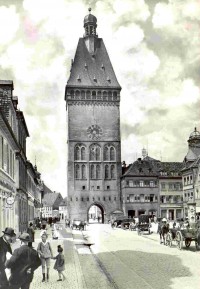
Das Altpörtel war das westliche Stadttor Speyers und Teil der mittelalterlichen Befestigung, zu der 68 Mauer- und Tortürme gehörten. Es bildet...

[Last update: ]

Usage and citation

The textual information presented here is free for non-commercial usage if the source is named. (Creative Commons Lizenz 3.0, by-nc-sa) Please name as source not only the internet representation but also the name of the museum.
Rights for the images are shown below the large images (which are accessible by clicking on the smaller images). If nothing different is mentioned there the same regulation as for textual information applies.
Any commercial usage of text or image demands communication with the museum.